
Проект развития и обустройства пешеходной экологической тропы «Меркитская крепость»
Aннотация
Развитие познавательного туризма на природных территориях на практике реализуется через перечень мероприятий проектирования и строительства пешеходных троп. Современные требования по организации цивилизованного доступа в природную среду подразумевают проектные решения по разработке и созданию атрибутов инфраструктуры экологической тропы, которые позволят сделать путешествия для посетителей безопасными и комфортными. Обустройство и реконструкция действующих троп производится с учётом требований ландшафта местности и применения современных методов и материалов. В статье представлены материалы проектирования экологической тропы на территории природного и историко-культурного объекта «Меркитская крепость» (г. Шара-Тэбсэг). В настоящее время в местности, приуроченной к «Меркитской крепости» функционирует необустроенная тропа регионального значения, набирающая популярность у местных посетителей и туристов. Рост туристского потока и времени пребывания путешественников на территории объекта посещения приводят к трудностям обеспечения экологически безопасного туризма. В статье дана оценка современного состояния и использования маршрута. Показаны особенности антропогенного воздействия на основное русло тропы. Продемонстрированы технологии проектирования и обустройства дорожного полотна экологической тропы, применимые к данной местности.
Ключевые слова: проектирование экологических троп, Меркитская крепость, природное и историко-культурное наследие, строительство троп, маршрут
К сожалению, текст статьи доступен только на Английском
Introduction. One of the current trends in the Russian tourist market, especially when the coronavirus pandemic will come to an end, is an increasing number of domestic tours, including ecological. At present, a greater number of city residents want to explore the areas of pristine nature with the aim of having a rest, studying and enjoying natural landmarks and cultural highlights. With the increasing number of visitors of natural areas, the impact of their trips on ecosystems also rises. To protect nature it is necessary to take into account mostly the influence the trip has on natural sites rather than the scope of tourism or tourists’ motivation of visiting this very place (Ledovskikh, 2002: 15). To identify the influence of a trip it is necessary to be aware of how a trip is organized and what is launched to follow sustainable development of the territory.
In the Republic of Buryatia, natural, historical and cultural site “Merkitskaya Krepost” (The Merkit Fortress) (Shara-Tebseg Mountain) possesses significant tourist and recreational potential. Here almost each and every cultural and natural landmark has its own history based on the presence of nomad tribes who inhabited this area during various periods of history. Speaking about the significance of this site, it has not only scientific and historical ones, but also it possesses some recreational value. Over the territory of “Merkitskaya Krepost” (The Merkit Fortress) a self-regulating hiking trail runs. And since the first half of 1990s, popularization of “Merkitskaya Krepost” (The Merkit Fortress) as a place of active and educational activity has been growing. Unfortunately, together with the increasing number of visitors the human impact on the main track of the trail is also raising. Among the consequences of such process there is natural soil erosion, destructive changes of body of the trail due to its poaching by visitors. All the above-mentioned causes threats during walking on the trail especially on difficult and steep parts of it where the risk of rock falls and crumbling of soil is observed. The tourists’ movement along Shara-Tebseg Mountain is mostly uncontrolled, its pristine areas are covered with the widening networks of small paths, visitors leave litter. The parking place is situated at the bottom of Shara-Tebseg Mountain that violates the conservative status of the natural site of federal significance – the mixed burial ground Khailasyn and can cause the mechanical damage to these archeological sites. Generally, the negative influence on the natural site and archeological monuments promotes arising a number of concerns. That is why there is a need for progress and development of an area that has good tourism carrying capacity for the economic sphere of the Republic of Buryatia.
The aim of the work. The aim of the article is the elaboration of the project of ecological hiking trail on the territory of the natural, historical and cultural site “Merkitskaya Krepost” (The Merkit Fortress) (Shara-Tebseg Mountain).
The objectives include identifying the current state of the trail usage, terrain analysis where the ecological trail is located (with the use of professional GPS navigation equipment), mapping the main points of the route and analysis of features of the major parts of the trails (such features as length, the basis of the trail body, the applied technologies during the construction of road of the trail).
Materials and Methods. Such methods as statistical analysis, surveillance, methodology of construction of ecological hiking trails were used. The research provides evaluation of the current state both of the trail itself and the area of Shara-Tebseg Mountain, the constructive suggestions considering improvement of the current unorganized trail are elaborated.
Results and Discussion. At present, one of the most popular archeological sites for tourists to visit in the Republic of Buryatia is “Merkitskaya Krepost” (“The Merkit fortress”). Nowadays, the name of this natural site is well-known thanks to the media and tour operators that have chosen this area as a place where it is possible to make a journey (Tashak, Ivanova, 2018: 74).
The historical and cultural heritage of the area with “Merkitskaya Krepost” (The Merkit Fortress) includes mixed tomb groups that are related to the Bronze and the Iron ages. The landscape of “Merkitskaya Krepost” (The Merkit Fortress) is represented by a number of natural and artificial objects, among them the ruins of the fortress that belonged to the tribe of Merkits (one of Mongolian tribes), eolian landforms (with kereksurs – burial stone cairns) and stone graves (Khailasyn), chains of ridges that remind the defensive earthworks and moats of the militant Xiongnu tribes (Imetkhenov, 2019: 86).
Evaluation of the current state of the unorganized hiking trails in the area and its usage shows environmental degradation at the corridor of the main part of the trail. The hiking trail represents the zone with intensive number of visitors. Since 1990s, the tourists flow to “Merkitskaya Krepost” (The Merkit Fortress) and adjacent territory has steadily grown. According to the data of OOO Tsentr Staroobryadtsev (The Centre of Old Believers), a limited liability company under the laws of the Russian Federation, that organizes tours to “Merkitskaya Krepost” (“The Merkit fortress”), about 4000-4500 of tourists visit the hiking trail in May and June. As for the unorganized tours, their number is impossible to count. But according to the surveillance of the non-governmental organization “Khailasyn” and the authors of this research, the territory of “Merkitskaya Krepost” (The Merkit Fortress) was visited by 400 random tourists just in one day (05.09.2020).
To determine the physical tourist flow capacity of the hiking trail in the territory of “Merkitskaya Krepost” (The Merkit Fortress), the same technology was used as for the natural area of Kwebrada Bonita (Khalikhman, Khalikhman, 2014).
The background information and parameters of the hiking trail “Merkitskaya Krepost” (“The Merkit fortress”):
- the visitors flow moves in one direction;
- each visitor takes 1 square meter;
- the minimal distance between groups of tourists is 50 meters;
- the maximum amount of people in one group equals to 15 visitors;
- the duration of the route is 3 hours;
- open hours from 6 a.m. till 6 p.m.;
- the length of the route is 5 200 meters.
If one visitor occupies 1 meter of the hiking trail, then one group occupies 15 meters. The recommended space between groups equals to 50 metres, then for 80 groups it is required 5 150 metres of the hiking trail (80*15 + 79*50). As a result, 80 groups of visitors take only 1 200 metres of the hiking trail taking the route simultaneously.
As this natural hiking trail can be visited 12 hours per day and the duration of the route is 3 hours, then a tourist can make 4 tours a day. So, the physical tourist flow capacity of the hiking trail “Merkitskaya Krepost” (The Merkit Fortress) equals to 4 800 visitors/visits a day (1200 meters*1 visitor per one meter* 4 visits per one day).
The major tourist flow visiting the Apricot Grove is observed in spring. This is due to the blossom of the relict apricot trees that grow on the territory next to Shara-Tebseg Mountain. This natural phenomenon depending on the weather lasts for approximately one week, rarely for two weeks. During the period of blossoming the number of visitors increases, consequently the human impact on the Apricot Grove and unorganized hiking trail “Merkitskaya Krepost” (The Merkit Fortress) rises as well. Almost all visitors arrive at this site by their own vehicles. The parking is located on the territory adjacent to the Apricot Grove that includes the object belonging to the historical and cultural heritage – the natural landmark of federal significance – “The mixed burial ground “Khailasyn”. Such parking place violates the conservation status of this landmark.
The visitors of the hiking trail unconsciously destroy the natural landscape of this site when displace some stones and erect the so called “turs” (artificial structures in the form of pyramids (fig 1).
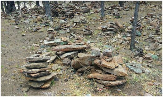
Fig. 1.«Turs» – artificial structures in the form of pyramids on the area of “Mertiskaya krepost” (“The Merkit fortress”)
Рис. 1. «Туры» – искусственныесооружениявформепирамид натерритории «Меркитскойкрепости»
During the short period of apricot trees blossoming this territory becomes a site with high concentration of visitors, and at this very time the natural body of the trail experiences a maximum human influence on it. This is due to the fact that one of the tour route points (beginning of the hiking trail) goes through the grove of the relic apricot trees on the south-west of Shara-Tebseg Mountain. The tourists’ movement along the hiking trails has a random and chaotic nature. At some points the hiking trail separates and converges, goes round the bushes of the relic apricot. All of these causes mechanical damage to branches, root system, trampling of new trees growth, undergrowth and mosses.
The picture below demonstrates the signs of forest environment degradation. At least 20 per cent of the relic apricot trees located closely to the hiking trail have mechanical damages. On the hiking trail directly, there is an absence of new growth, undergrowth and mosses. Speaking about the edges of the hiking trail, here a slight amount of undergrowth and new growth still can be observed but they are very rare, also, some died samples of the undergrowth and new growth can be seen.
The starting point of the ascent of Shara-Tebseg Mountain mostly consists of mineral parts of soil and presents rock particles of different sizes (fig. 2).
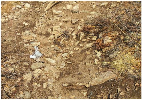
Fig. 2. The mineral part of soil of the hiking trail
Рис. 2. Минеральная часть почвы на тропе
The mineral part of the soil is represented by sharp rock particles at comparatively steep slopes (over 25-30º) and rock falls pose risk for visitors and their movement along the hiking trail.
All types of soils having the slope over 20 per cent can be referred to places with the high level of erosion appearance. Except the human negative impact on the environment of the hiking trail natural causes exist too, including spring floods and heavy summer rainfalls. During the spring floods the erosion of soils is observed that leads to changes in the natural body of the trail (holes, potholes and rising grounds appear).
According to the classification of ecological tourist trails in the central ecological zone of the Baikal natural area, the unorganized hiking trail on the territory of Shara-Tebseg is classified as of difficult level (the width varies from 0.3 till 0.6 meters, the slope is about 20 per cent) and of the most difficult level (the width varies from 0,3 till 0,6 meters, the slope is about 40 per cent) (Decree of the Government of the Republic of Buryatia). As the hiking trail “Merkitskaya Krepost” (The Merkit Fortress) includes a number of complex points, taking it can be uneasy for physically untrained people, so the full completion of the route is available for a limited number of visitors. The major part of them, especially families, take only 1/3 part of the route, bypassing the toughest but at the same time the most attractive points of the hiking trail.
Development of the modern ecological hiking trail meeting all necessary requirements of safety and comfort is long overdue. Improvement of the hiking trail and up-to-date body of the trail provide opportunities for people’s health improvement regardless of their physical state and age.
In general, unorganized hiking trails on the territory of Tughui Pillars of the area “Khailasyn” including “Merkitskaya Krepost” (The Merkit Fortress) have been existing for more than 30 years. As for the main groups of people that visit these hiking trails, there are the following:
- backpackers, who come on their own vehicles with the aim to have a rest or walk on tough terrain;
- organized tourists, who participate in the educational and ethnographic tours organized by the local tour operators and their main goal is to have a rest;
- local visitors, for example schoolchildren and adults who are from the nearest settlements.
The most advantageous direction of the route elaboration is the existing unorganized hiking trail. Such factors as the desolate territory, lack of plantings, passability and visibility contribute to the choice. Moreover, the improvement of the hiking trail will bring a more positive impact than transferring the hiking trail from one place to another. Among the negative sides of transferring of the route – doubling of environmental damage and lasting erosion of the previous hiking trail.
The development of the route of the hiking trail was performed with the use of professional navigation equipment (Garmin Oregon 550). The route was conditionally divided into 8 main parts and the draft of a quick-map of the ecological hiking trail was developed (fig. 3).
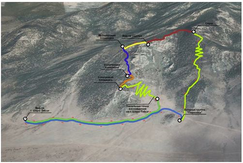
Fig. 3. A quick-map of the route of the ecological hiking trail “Merkitskaya Krepost”
Рис. 3. Карта-схема маршрута пешеходной экологической тропы «Меркитскаякрепость»
Description of the route parts (length, main characteristics, peculiarities, materials, activities, etc.):
The general length of the ecological hiking trail “Merkitskaya Krepost” (The Merkit Fortress) is 5200 meters.
The first part of the route of the hiking trail. The entrance group the “Parking place” provides a view on Shara-Tebseg Mountain. The trail head on the entrance group is elaborated close to the car parking, that is used as the nearest way to reach the hiking trail. Structural peculiarities of this part of the route: the length is 840 meters. Parking capacity equals to 20-30 vehicles. The first part of the route is equipped with a sign of the parking place and a parking gate arm.
The second part of the route of the hiking trail. This starts from the view on Shara-Tebseg Mountain and goes down to the starting point of ascent onto Shara-Tebseg Mountain. The length is 1040 meters. The given part of the route has self-built structures such as an awning with benches and a bonfire site. On the opposite side from the awning there are two wooden public conveniences.
According to the Report of the meeting in the Tarbagatai region of 15 October 2019 headed by the Minister of Tourism of the Republic of Buryatya M.B. Badmatsyrenova, where the perspectives of the development of the project “Merkitskaya Krepost” were discussed, it is planned to transfer the awning, benches, a bonfire site and public conveniences outside the territory of Khailasyn area. Instead of self-built structures the erection of solid beam benches will be performed, as well as setting of dry latrines.
Along the path of a route, there are at least four clean, clear and safe places that are suitable for organizing observation points on them. It is proposed to equip the first three observation points with solid beam benches to offer a short rest for the visitors. The main idea of design of observation points is to make then similar to the natural landscape.
The third part of the route of the hiking trail runs from the starting point of ascent onto Shara-Tebseg Mountain to the first observation point. The length of this part equals to 580 meters. The starting point of ascent onto Shara-Tebseg Mountain is equipped with an information desk where the general information concerning the ecological hiking trail and the area is given (the length, rules of behavior, major points of the route in the form of a quick-map). To preserve natural landscape in the process of the ecological hiking trail development it is proposed to use the local types of stones.
As a slope of a mountain during climbing it through the Apricot Grove is rather tough (over 25°), it becomes difficult for some groups of visitors to climb the mountain. That is why the elaboration of the hiking trail along the slope is necessary to perform under the principle of serpentine with the construction of turning points, plastic geogrids for slopes strengthening as well as the usage of erosion-preventive structures and enhancement of the fundamental strength of the body of the hiking trail (fig 4, 5).
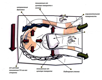
Fig. 4. Arrangement of turning point on the serpentine
Рис. 4. Устройство поворотной площадки на серпантине
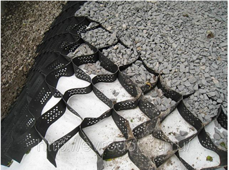
Fig. 5. Plastic geogrids of low pressure
Рис. 5. Полиэтиленоваягеорешетканизкогодавления
The fourth part of the route of the hiking trail. It starts from the first observation point to the second one. Its length is 200 metres. This part of the hiking trail allows to see the picturesque panorama of Tugnuiskaya Valley. This part of the route should be constructed with the erection of stone stairs and edge protection. Here rock falls and crumbling of the soil are possible.
The fifth part of the route of the hiking trail. The length equals to 550 metres. The construction peculiarity is presented by the extremely rugged terrain. Also, being aware of the slope issue is of high importance.
The sixth part of the route of the hiking trail. This part of the hiking trail runs from the third observation point to the place offering views of the rift. The length is 150 metres. This part of the route is characterized by a rather sharp climb and necessity of stone stairs and edge protection.
The seventh part of the route of the hiking trail. The length of this part is 490 metres, and it requires the erection of edge protection.
The eighth part of the route of the hiking trail. Its length equals to 1380 metres. It is the longest and the most difficult part of the route. The main obstacle is the steep long descent. This part of the hiking trail requires some work with slope issues, erection of stone stairs and turning points on the serpentine.
The use of technologies and materials should be in accordance with peculiarities of the hiking trail profile and includes the following special services:
- excavation of the body of the hiking trail;
- setting up of walking areas, drainage frame, smoothing;
- rock installation (usage of coarse fraction equals to 5-7 cm and fine fraction by separation);
- erection of drainage system;
- erection of turning points on serpentines;
- installation of geogrids and filling them with free-flowing fillings at turnings and at places with possible risk of rock falls for strengthening;
- setting up signs of the route explanation;
- manual excavation;
- hand loading of uncompact soil from pilings into specialized vehicles;
- compaction of soil by air earth rammers;
- design of sketches of observation points, parking place, information desks, signs.
Conclusions. Prohibitive measures designed to reduce the number of visits of the natural landmark “Merkitskaya Krepost” (The Merkit Fortress) are useless both in protective and economic aspects and difficult to implement in practice. Rapid development of ecological and educational tourism on the basis of their good organization bring economic dividends. To elaborate touristic activity it is necessary to keep an interdisciplinary approach for the development of natural areas to minimize the negative impact of travelling to historical, cultural and social environment. Creation of the hiking trail with the length of 5 200 metres and equipping it with information materials allows to manage the visitors’ movement along the trail, to provide safe access to natural landmarks as well as helps to localize the tourist flow. The well-planned and proper infrastructure development of the ecological hiking trail makes it possible to maintain the order and to remove rubbish in time.
The implementation of the project allows to draw attention of tourists of different ages to this area, encourages people with different physical conditions to enjoy outdoor activities, to improve their health and to experience educational and ecological types of tourism. The increase in visitor numbers of the hiking trail provides a great opportunity for the local inhabitants to earn money producing and selling craftwork items. Also, the tourism supra-structure of cross-border regions will evolve.
Moreover, the ecological hiking trail will create additional fire prevention lines. The paths of the hiking trail will be used as a means to get fire units to seats of fire. In the long term, the number of paths that constitutes “Merkitskaya Krepost” (The Merkit Fortress) can be increased by laying radial line routes that can become integrated parts of the main organized hiking trail.
Conflicts of Interest: the authors have no conflict of interests to declare.
Информация о конфликте интересов: автор не имеет конфликта интересов для декларации.


Список литературы
Список использованной литературы появится позже.